An old network of roads exists along the washes of McDowell Mountain Regional Park, the Fort McDowell Yavapai Nation, and even some parts of Fountain Hills. Some stretches are more visible, while others barely stand out from the landscape. The most significant of these old roads was the Stoneman Road, and not many people today know about it.
What was the Stoneman Road
The Stoneman Road was a military supply road that connected Fort Whipple (near Chino Valley) to Fort McDowell from approximately 1870 to 1890. The road got its name from George Stoneman, a cavalry officer for the Union during the Civil War. The map of the region looked a lot different back in those days. There was no Fountain Hills, no Regional Park. Fort McDowell existed, but it was just a few crumbling adobe buildings. The Yavapai Reservation did not officially exist in the area until 1903. Also, the Pemberton and Box Bar Ranches were still decades away.
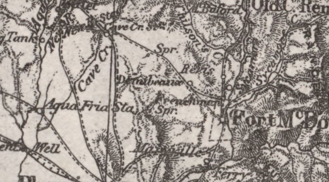
In this 1887 map, the uppermost dotted line is the Stoneman Road.
If you’re looking at maps of trails anywhere between McDowell Mountain Regional Park and Prescott and you see trails marked “Stoneman Trail,” “Military Road,” or “Whiskey Bottle Trail,” then you’re most likely looking at the most intact pieces of the original Stoneman Road route.
When and Why did it exist
The path that became the Stoneman Military Road was originally a series of paths that the native Americans used, likely for centuries. President Ulysses S. Grant assigned George Stoneman to command the cavalry of Arizona Territory in 1870. Stoneman quickly realized that Fort McDowell was really far away from most supplies. He found the old Native American paths that passed north of the McDowell Mountains. He realized that a new supply route to Fort Whipple using these paths could skip Phoenix entirely and shorten the journey by more than a day. You can learn more about the significance of the Stoneman Road at azmemory.azlibrary.gov.
A fragment of the Stoneman Road, by Mark Henle / The Republic
With the road complete, the productivity of Fort McDowell greatly improved, bringing the place from a few buildings on the brink of ruin to a well-maintained military installation. Eventually, the military abandoned the fort when the first reservation in the area formed in 1890. When this happened, the Stoneman Road went into disrepair pretty much immediately. By the time the Fort McDowell Yavapai Nation was formed in 1903, the Stoneman Road had either been subsumed into more modern roads or abandoned completely.

An 1879 map showing Fort McDowell (right) and the Stoneman Road shown as a diagonal line leading to Cake Creek through two landmarks labelled “Frenchman” and “Dernbauer(?)”
You can check out a small monument to the road on the Stoneman Wash Trail in
McDowell Mountain Regional Park. That trail includes one of the path’s longest continuous remaining pieces. While not much else remains, the Stoneman Road is one of the most notable constructions in our area from the 1800s.


