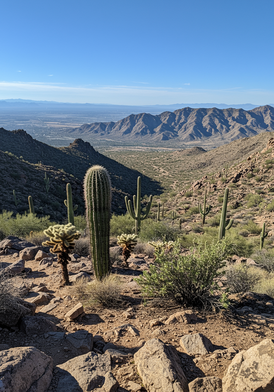
The cooler weather makes November the perfect time of year to go hiking around Fountain Hills. This Fall you can take your adventurers to the next level by participating in the Fountain Hills Hiking Challenge!
This year’s hiking challenge includes two levels, an easier (shorter) and a challenging longer with more elevation series of the best hiking trails in Fountain Hills, totaling over 34 miles. New this year are the guided hikes with the
Steward of the Sonoran Conservancy of Fountain Hill. Sign up and enjoy the company of fellow hikers while exploring the longer tails at
Fountain Hills Park and Rec.
The challenge, which is proudly sponsored by the Sonoran Lifestyle Team at RE/MAX Sun Properties, begins on November 1st, and lasts for the entire month. SPECIAL BONUS! Stop into the RE/MAX Sun Properties (
Sonoran Lifestyle team office) for a printed map of all local trails. We’ll have a goodie bag with handy gifts selected especially for hikers. Stop by anytime in November, Mon-Fri, 10a-5pm. Our address is 16824 E. Avenue of the Fountains, Suite 12, in Fountain Hills.
The registration Fee is $15 for the Hiking Challenge. All registered participants will receive a commemorative Fountain Hills Hiking Challenge T-shirt. Complete the long or short-challenge hikes.
Registration Here share your pictures on social media to be entered to win a $50 gift card to
Just Roughin’ It. Share your hiking pictures by tagging @fhparksandrec on Facebook.
Whether you're an experienced hiker seeking to challenge your endurance or a beginner eager to explore new trails, Fountain Hills provides a diverse selection of routes suitable for all skill levels. After your hike, explore available
Fountain Hills homes for sale to ensure a comfortable retreat for your next adventure.
The Short Challenge
FOUNTAIN HILLS DESERT BOTANICAL GARDEN – 1.2 MILES – EASY OUT AND BACK WALK
The Garden offers an easy hike on 8 acres of the native Sonoran Desert. The trail has informative signs. The Garden is also an
eBird site. It is located on Fountain Hills Boulevard about 1.5 miles south of Palisades.
LAKE OVERLOOK TRAIL – 1.5 MILES – EASY LOOP HIKE
Said to be one of the best views in Fountain Hills, this easy hike rises 300 feet above Fountain Park offering panoramic views of the mountains surrounding the town. Marked access is just east of Saguaro on Panorama Drive or further east on Panorama near the parking lot. When you reach La Montana Blvd, follow the signs a short distance to continue the trail.
OVERLOOK TRAIL – ADERO CANYON TRAILHEAD – 1.2 MILES-MODERATE OUT AND BACK HIKE
From the Adero Canyon Trailhead parking lot, go through the gate. The sign posted Overlook Trail begins on your right. You might want to have a hiking pole for this hike as you will hike up to a very scenic overlook. At the top, there is a diorama that shows the mountains and other points of interest. On the way back to the trailhead, you can detour on the Easy Trail to extend your hike by about .2 miles.
WESTERN BIKE TRAIL – ADERO CANYON TRAILHEAD – 1.5 MILES-MODERATE OUT AND BACK HIKE
From the Adero Canyon Trailhead parking lot, go through the gate. The sign posted Western Bike Trail will be found on your left. This trail winds up to the Andrews Kinsey Trail. You will have views of Adero Canyon the entire way. Once you reach the Andrews Kinsey Trail turn left and follow it to the sign for the McDowell Sonoran Preserve. Return the same way.
PROMENADE TRAIL – ADERO CANYON TRAILHEAD – 1.6 MILES-MODERATE OUT AND BACK HIKE
From the Adero Canyon Trailhead parking lot, the Promenade Trail begins after the gate. It follows an old jeep road for .8 miles with scenic views the entire way. The first uphill is the only difficult part of this hike. Once you reach the signposted Sonoran Trails return to the trailhead. If you wish to go further, hike the Lower Sonoran Trail a short distance to the sign-posted Scenic Overlook. Return the same way you came.
Long Challenge
SONORAN LOOP – ADERO CANYON TRAILHEAD – 5.5 MILES-MODERATE TO MODERATELY DIFFICULT
From the Adero Canyon Trailhead, go through the gate and follow the Promenade Trail (an old jeep road) to its end to the Sonoran Trails. The Sonoran Trail and Lower Sonoran Trail form a loop. You can shorten the loop by taking one of two marked crossover trails. Do not pass the entrance sign for the McDowell Mountain Regional Park you have gone too far and missed the turn!
DIXIE MINE – GOLDEN EAGLE TRAILHEAD – 5.4 MILES – MODERATE
From the Golden Eagle Trailhead at the end of Golden Eagle Blvd, follow the marked sidewalk and signs to the entrance to McDowell Mountain Regional Park ($2.00 fee required). Follow the Dixie Mine Trail to a road. Turn right and go down a short hill. At the bottom of the hill, turn left on an unmarked trail that will take you a short way to the Dixie Mine. Return the way you came.
WESTERN LOOP – ADERO CANYON TRAILHEAD – 2.6 MILES – DIFFICULT
From the Adero Canyon Trailhead, go through the gate and take the signposted Western Bike Trail on your left. When the trail meets the Andrews Kinsey Trail, turn left and follow a short distance to the Western Loop Trail. The WesternLoop Trail climbs steeply to a scenic view. The trail continues and descends steeply to the Promenade Trail. Return to the trailhead on the Promenade.
ANDREWS KINSEY TO THE HITCHING POST – ADERO CANYON TRAILHEAD – 6 MILES – MODERATELY DIFFICULT
From the Adero Canyon Trailhead, go through the gate and take the signposted Western Bike Trail on your left. When the trail meets the Andrews Kinsey Trail, turn left. The trail climbs as it winds through the Adero Canyon to the Sunrise Trail with the hitching post. Return the way you came. For an extra challenge take the Sunrise Trail to the top of Sunrise Peak.
RIDGELINE TRAIL – ADERO CANYON TRAILHEAD – 4 MILES – DIFFICULT
From the Adero Canyon Trailhead, go through the gate. The signposted Overlook/Ridgeline trail begins on your right. This trail follows a ridge overlooking Adero Canyon. The Lower Ridgeline provides an optional 1-mile loop starting at mile marker R2 and ending at mile marker R4. Near the eastern end of the Lower Ridgeline, there is a 0.2-mile spur leading to an overlook.
DIXIE MINE TO ADERO CANYON – GOLDEN EAGLE TRAILHEAD-5 OR 10 MILES MODERATELY DIFFICULT TO DIFFICULT
This hike can be done as either a round trip 10-mile hike or shortened to a one-way 5-mile hike if another car is left at the Adero Canyon Trailhead. From the Golden Eagle Trailhead at the end of Golden Eagle Blvd., follow the marked sidewalk and signs to the entrance to McDowell Mountain Regional Park ($2.00 fee required). Follow the Dixie Mine Trail to the Sonoran Trail. When you enter the McDowell Mountain Preserve, you can follow either the Sonoran Trail or Lower Sonoran Trail to the Promenade Trail. Follow the Promenade Trail to the Adero Canyon Trailhead where you can take a break before returning the same way or phone for a ride home!